
The hill that separates Sawang and Olo-olo. Below it is the expanse of protected corals and fishing refuge. (Photo by Clemente Bautista Jr/Bulatlat)

By CLEMENTE BAUTISTA JR.
Kalibutan
Four days prior to Holy Week, I asked my son Karlos if he would like to go on a long bike ride somewhere in Batangas. We are both mountain bike (MTB) enthusiasts, and whenever we had a chance, long bike rides have been a form of father-son bonding for us.
One of our most memorable long rides was last December 26, 2016, while Typhoon Nina whipped Southern Luzon. In the midst of stormy winds and heavy rains, we biked the circumference of Taal Lake for about nine hours, covering 130 kilometers. It was a thrilling and dangerous ride. Karlos said after the ride: “On hindsight, riding your bike in a storm was stupid. Yes, it was fun, but am I risking my life for fun?”

Catandala passage. (Photo by Clemente Bautista Jr/Bulatlat)
This Holy Friday’s ride was different. Even without the beating rain and deathly winds, Karlos and I were just as thrilled. We were riding to the last frontier of a southern Luzon province, the coastal municipality most adjacent to the world’s center of the center of marine biodiversity: Lobo, Batangas.
It was a fulfilling ride in a route packed with scenic views, history, and lessons about how people can always choose to protect nature.
From our jump-off point in Tanauan City, Lobo is about 65 kilometers away. We took the Tanauan-Lipa-Ibaan-Taysan route, which takes a “medium” level of effort for weekend riders like us.
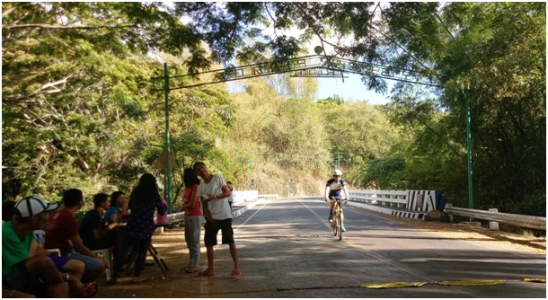
We passed through Catandala Passage, a dangerous and curvy road in Catandala village, Ibaan town. We considered this the most challenging part of the ride.

Some part of the Taysan-Ibaan Road have railings to keep vehicles from running off into the deep ravine. (Photo by Clemente Bautista Jr/Bulatlat)
At the bottom of the passage is the beautiful Calumpang River. The water is clean and clear due to the relatively good watershed. This river has remained to be a public commons and a destination of locals for their leisure.

Children frolic in Calumpang River. (Photo by Clemente Bautista Jr/Bulatlat)
From Taysan to Lobo, the road is a mix of rising and dipping zigzags. Most part of the hi-way was newly constructed. Though it is a nice training ground for your biking skills, be aware that the route is plagued with deep ravines.
It took us more than four hours to get to Lobo. As we approached the town, a warm feeling of nostalgia hit me. It was there where my colleagues in Kalikasan and I have campaigned against the Australian mining company Mindoro Resources Limited (MRL). Since mid 2000’s, this foreign mining company has applied for permit to mine Mt. Lobo. Back in 2015, Batangueños have thwarted the almost ‘good-to-go’ operations of MRL. The people’s protests eventually forced the national and local governments to reverse the permit given to the mining company.
We went directly to Lagadlarin village, a fishing community which hosts the Lobo Mangrove Conservation Area. Lagadlarin is one of the many communities that stood against the MRL mining. As their primary livelihood is fishing, people know that once MRL starts its operation, it will pollute and contaminate their rivers and sea.
Locals put a ‘toll station’ along the road to collect donation from passing motorists. (Photo by Clemente Bautista Jr/Bulatlat)
Aside from the entry of extractive companies, Lobo is also fast becoming a tourist attraction, and many fishing communities are threatened to be displaced. Land speculators, rich landlords and corporations are hurrying to privatize these public commons.
After we took our lunch and had a siesta at our friends’ house, we went snorkeling in another protected area called Sawang Olo-olo Fish Sanctuary and Refuge Area, commonly known as Submarine Garden, due to the teeming marine life.

(Photo by Clemente Bautista Jr/Bulatlat)
The waves were rough, blurrying the view of the sea garden, but we still managed to see various fishes and corals. Villagers say the best time to dive is in the early morning when the tide is low, the waves are calm and the water is clear. My unsolicited advice is, if you’re not a good swimmer, make sure you go with someone who is a strong swimmer or diver.

Rocks and coral formations can be seen under the the Sawang Olo-ol Fish Sanctuary and Refuge Area (Photo by Clemente Bautista Jr/Bulatlat)
From the Submarine Garden, we rode our bike to the Malabrigo Fish Sanctuary and Refuge Area and the Malabrigo Lighthouse. It is a 10-kilometer uphill ride from Lagadlarin, and we spent at least 30 minutes to get there.
The Faro de Punta de Malabrigo or Malabrigo Lighthouse was constructed during the Spanish colonial years. The light house began operation in 1896, the same year that the Katipuneros lit the Philippine Revolution. It is on the top of a hill which overlooks the Verde Island and Mindoro Oriental. The provincial government has already modernized some of the equipment of the structure. It now uses halogen lamps for its light and gets its power from solar panels.

(Photo by Clemente Bautista Jr/Bulatlat)
Conservation areas such as the Malabrigo fish sanctuary and Sawa Olo-olo are part of the government’s way to conserve the marine ecosystem. While this has a positive impact on the environment, protected areas have adversely affected local fishermen. Fishing is strictly prohibited, resulting to the decrease in the fisherfolk’s daily catch. Even private resort owners also prohibit small fishermen, who only have their paddle bancas for fishing.
Adding to these are restrictions, even more taxes and heavy fines courtesy of the amended national Fisheries Law. Fisherfolk say these have been a burden for them and their families in Lobo.
After a long, tiring day of biking and swimming, we parked our bikes for the night on the shore of Lagadlarin. We sipped our drinks, rapt in the light of the moon rising over the horizon of Mt. Lobo.

The setting sun casts its dying light over Malabrigo shore. (Photo by Clemente Bautista Jr/Bulatlat)
Indeed, Lobo is a paradise, a perfect travel destination for anyone. As we enjoy its beauty, we should also educate ourselves about its delicate ecological balance, the people who are protecting it, and the relentless threats from profit-oriented companies. We should support the struggles against the destruction of environment and privatization of the public commons. This way, we are assured that the adventure and magnificence of Lobo will always be there to enthrall us.

(Photo by Clemente Bautista Jr/Bulatlat)
Clemente Bautista is the national coordinator of the Kalikasan People’s Network for the Environment, a national environmental campaign center established in 1997.
![]()
 Save as PDF


0 Comments